
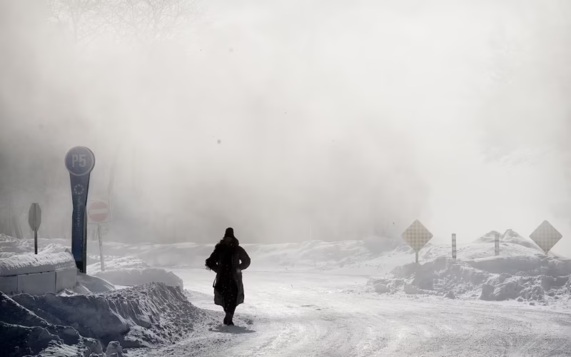
Ottawa (Rajeev Sharma): An intense Arctic cold wave has gripped most of Canada this weekend, prompting widespread cold weather warnings from Prince Edward Island to eastern Alberta, as a powerful polar vortex drives temperatures to dangerous lows.
Environment and Climate Change Canada (ECCC) warned that wind chill values in parts of the Prairies could feel as cold as –55°C, as an Arctic air mass settles firmly over the country. The extreme cold is expected to persist through the weekend before conditions gradually improve in some regions.
ECCC meteorologist Trudy Kidd said the cold snap is linked to a weakened polar vortex — a swirling mass of frigid air usually confined to the Arctic. “When it weakens, Arctic air can travel south,” Kidd explained, allowing severe cold to spread across large portions of Canada.
Prairies Face the Harshest Conditions
Eastern Alberta is experiencing wind chills between –40°C and –45°C, while Saskatchewan and Manitoba remain under orange-level warnings, with overnight wind chills dropping to –45°C to –50°C. Authorities cautioned that although daytime conditions may improve slightly, extreme cold will return each night for several days.
The deep freeze has disrupted daily life, forcing school and bus service cancellations in Manitoba and complicating emergency response efforts in Winnipeg, where fire crews have struggled with frozen equipment. Several winter recreation facilities, including ski trails, have temporarily shut down due to safety concerns.
Eastern Canada Under Cold and Snow Alerts
Northwestern Ontario, from Fort Severn to Fort Frances, could feel temperatures as low as –48°C overnight. Southern Ontario and Quebec are under yellow-level warnings, with wind chills nearing –40°C. Southern Ontario is also bracing for a snowstorm expected to dump 20–30 centimetres of snow on Sunday.
In Quebec, wind chills between –45°C and –50°C are forecast in northern regions, while parts of southern Quebec could see 10–20 centimetres of snow beginning Sunday evening.
Atlantic Canada Also Affected
Prince Edward Island and New Brunswick are experiencing wind chills of –30°C to –35°C, with brief but intense snowfall expected in northeastern New Brunswick, reducing visibility and impacting travel.
Health and Safety Concerns
ECCC warned that frostbite can develop within minutes on exposed skin under these conditions. Canadians are urged to dress in layers, ensure outer clothing is wind-resistant, and watch for symptoms such as numbness, colour changes in fingers and toes, muscle weakness, chest pain, or shortness of breath.
Vulnerable populations — including young children, seniors, people with chronic illnesses, outdoor workers and those without adequate shelter — face heightened risks. Authorities are encouraging residents to check on neighbours and family members during the cold snap.
Vehicle and Power Preparedness
Canadians are advised to prepare emergency kits in case of power outages and keep essential supplies in their vehicles, including blankets, jumper cables and flashlights. Automotive experts recommend using block heaters to protect engines, while electric vehicle owners are cautioned about reduced battery range in extreme cold.
Climate Change Context
While global temperatures continue to rise, scientists note that short-term and regional cold snaps can still occur. Researchers emphasize that no single weather event disproves climate change, adding that extreme cold events are becoming less frequent overall, though still possible.
Meanwhile, southwest British Columbia remains a notable exception, with mild conditions and early-blooming cherry blossoms reported in parts of Metro Vancouver.